Remnants of Hurricane Ida
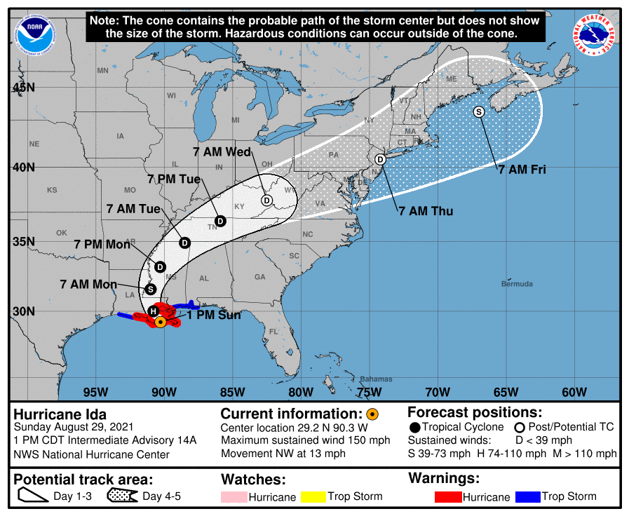
National Hurricane Center intermediate advisory at 1 PM on Sunday August 29th, 2021. This was around the time of landfall, and depicts the forecast track for the next 5 days.
On the morning of August 26th, 2021 the National Hurricane Center began issuing advisories on Tropical Depression 9 (what would become Hurricane Ida). Later that night, Tropical Storm Ida was born. After passing over Cuba, it rapidly intensified as it moved over the warm waters of the Gulf of Mexico. On August 29th Hurricane Ida would make landfall near Port Fourchon in southeastern Louisiana around noon as a powerful Category 4 hurricane, with sustained winds of 150 mph. The remnants of Ida would track through the southeastern U.S. Monday and Tuesday.
Meanwhile, a stationary front sat over the Northern Mid-Atlantic through this time. As tropical moisture streamed into our region, amid strengthening wind shear aloft, a supercell thunderstorm traversed the region overnight Tuesday September 1st from Charlottesville to Baltimore - passing over the northwestern Washington suburbs. This thunderstorm dropped 2-4 inches of rainfall in less than an hour in many places. This resulted in flash flooding in some areas along and just west of the I-95 corridor, with the northwestern Washington suburbs seeing the worst of it.
Later on Wednesday afternoon, September 1st, the remnants of Ida and its tropical moisture ran directly into the stalled frontal boundary over the region. This resulted in heavy rainfall and severe thunderstorms, bringing widespread flooding and several tornadoes to the Mid-Atlantic and Northeast. In our region, widespread flooding was observed across the eastern WV panhandle and western/north-central/& northeastern MD. Areas along the MD/PA border received anywhere from 3-6 inches of rainfall, with areas around Frederick, MD picking up 8”. Additionally, 2 tornadoes were observed in central & northeastern MD, one of which reached EF2 intensity over Annapolis, MD. Both tornadoes were associated with the same supercell, which formed over southern MD and tracked all the way to the Mason-Dixon line.
Flooding
Two day precipitation totals on September 1st-2nd, 2021.
Over a 24 hour period, much of the area received 2-4 inches of rainfall, with some areas receiving 5-8 inches, especially near Frederick, MD and in northwestern Cecil County.
For many along the I-95 corridor, the rainfall came in 2 rounds, with a heavy shot coming overnight Tuesday into Wednesday. That was in association with a supercell thunderstorm that traversed the area from central VA and up the I-95 corridor into Cecil County. While not directly Ida related, the tropical moisture ahead of Ida interacting with a stalled frontal boundary fueled this event. Some flash flooding occurred with this storm during this time period, particularly over southern Montgomery County, where Rockville and other nearby suburbs were hit particularly hard. Some locations measured 3-4 inches of rain within 45 minutes.
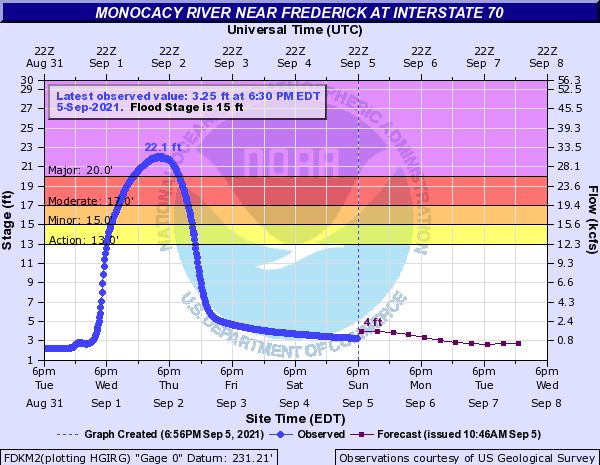
For the rest of the area, the majority of the rainfall came directly from the remnants of Ida during the early morning and daytime of Wednesday. Northern Maryland and eastern West Virginia saw 2-5 inches of rain throughout the day, with Frederick County, MD seeing the bullseye (up to 8 inches reported in some spots). This led to dozens of instances of flooding in these areas. The Monocacy River near Frederick had major river flooding, it’s eighth highest crest on record, and it’s highest crest in 25 years - since the two Potomac Basin floods of 1996. Minor to moderate flooding occurred along the Potomac River with this event. With lesser rainfall in their basins, the Shenandoah and Rappahannock Rivers largely avoided flooding.
Hydrographs showing major flooding on the Monocacy River in Frederick, MD on Wednesday September 1st, 2021.
Tornadoes
Here are the preliminary reports for the two tornadoes that struck central Maryland on Wednesday afternoon, September 1st, 2021.
On the maps:
* Blue triangles represent EF-0 damage,
* Green triangles represent EF-1 damage
* Yellow triangles represent EF-2 damage
* The paths are color coded to the maximum intensity anywhere on the track.
Anne Arundel/Annapolis MD:
Anne Arundel/Annapolis Tornado Track
Rating: EF-2
Estimated Peak Wind: 125 mph
Path Length /statute/: 11.5 miles
Path Width /maximum/: 200 yards
Fatalities: 0
Injuries: 0
Start Date: Sep 1 2021
Start Time: 2:01 PM EDT
Start Location: Owensville, MD
Start Lat/Lon: 38.850 / -76.596
End Date: Sep 1 2021
End Time: 2:23 PM EDT
End Location: 1 mile north of Annapolis, MD
End Lat/Lon: 39.001 / -76.509
Survey Summary:
THE INFORMATION IN THIS STATEMENT IS PRELIMINARY AND SUBJECT TO CHANGE PENDING FINAL REVIEW OF THE EVENT(S) AND PUBLICATION IN NWS STORM DATA.
The remnants of Ida produced one of the strongest tornadoes in the past decade of Maryland's history. Only four other EF2 or stronger tornadoes have occurred in the state in the past 10 years.
On Wednesday afternoon, a tornado that peaked in intensity with winds estimated at 125 mph traveled northeast along a path through Anne Arundel County and the City of Annapolis. It not only snapped numerous trees, but also produced significant structural damage to homes, businesses, and a school. Fortunately, there were no injuries reported, even though it tracked through a heavily populated area. Several eyewitnesses to the event reported getting the NWS Tornado Warning through their cell phone in advance, and sheltering in response to the warning.
From the NWS storm survey, the first damage noted, and recorded touchdown point was in Owensville, Maryland, in southern Anne Arundel County, near the intersection of Sudley Road and Owensville Road. This included a large limb from a tree top over Sudley Road and several portions of large cedar trees snapped along Owensville Road. The tornado moved northeast across rural southern Anne Arundel County before crossing Mill Swamp Road. Here, about a quarter of a mile east of the intersection with Dove Farm Road, dozens of trees and large branches were snapped and uprooted in a path from southwest to northeast as far as you could see in either direction from the road. While the dominant direction of the tree damage was being blown down to the north or northeast, there were trees downed in multiple directions, and many were topped.
The tornado intensified further as it moved into the South River Colony community. Dozens of trees were downed along the easternmost portions of Monarch Drive. Homes near the intersection of Monarch Drive and Red Admiral Court were particularly hard hit by some of the strongest winds of the entire tornado path. Several had significant portions of their roof damaged or removed, and one home in the middle of the track was unroofed entirely. One resident in this area reported seeing the tornado as it approached. The tornado then crossed South River Golf Links before moving into a campus of school buildings that includes South River High School and the Center of Applied Technology South. There it damaged the upper parts of the football field grandstands and concessions stand, damaged the roof, and caused cosmetic damage to some of the upper portions of the Center of Applied Technology South. The schools were left structurally sound, and the staff and some students that were there were able to shelter without injury.
The tornado crossed Central Avenue around 2:11 PM and moved into Edgewater. Here it crossed the communities of Woodland Beach, Londontowne, and Edgewater Park. Dozens of trees and large branches were snapped, and portions of 5 to 10 roofs were noted to have been damaged. One home near the intersection of Millstone Drive and Oakwood Road had only damaged roof trusses remaining of its roof.
The tornado crossed the South River and moved through western portions of the City of Annapolis at peak intensity with winds estimated at 125 mph at 2:20 PM. Several trees were snapped along the path as it crossed Aris T. Allen Boulevard just east of the Annapolis Harbour Center shopping area. It crossed Forest Drive at the intersection of Parole Street. Several homes there sustained roof damage, and one home was unroofed entirely. As it crossed the area near the intersection of West Street and Lee Street, the most substantial structural damage was noted. A large warehouse building had the winds enter the south side of the building and blow out a large portion of the west side cinder block wall. The roof with large metal trusses was largely removed. A fast food restaurant had its sign entirely removed from its post. Another commercial building had its roof removed, significant upper portions of the cinder block building removed, and its large commercial sign post blown over. A strip mall across the street had its windows blown out and flat roof damaged. All the telephone poles and attached wires along this stretch of West Street were downed. Another commercial building had its windows blown out. Several eyewitnesses saw the tornado as it passed.
Additional residential roof damage occurred as the tornado moved north over Bowman Court. From here, the tornado crossed into the community of Admiral Heights. Affected were areas along Halsey Road and adjacent Cedar Park Road. Here, the wind did not directly cause any structural damage, but about a dozen trees were snapped. That included one large, healthy tree about two and a half feet in diameter. The tornado crossed Weems Creek and Rowe Boulevard, and then snapped several trees along Riverview Avenue.
Finally, the tornado crossed US Route 50/301 a few hundred yards west of the Severn River Bridge, snapping trees on both sides of the highway. The final damage noted occurred at the end of Acorn Drive at the last residential property that sits on the shore of the Severn River. Several trees were snapped here. The tornado dissipated here, or as it crossed the Severn River. The survey team was not able to find any damage north of the Severn River, and video evidence from social media indicates the funnel dissipated here.
The National Weather Service Baltimore/Washington thanks the first responders and the Offices of Emergency Management of the City of Annapolis and Anne Arundel County, who all provided invaluable support for this storm survey.
Baltimore County/Edgemere MD:
Baltimore County tornado track
Rating: EF-0
Estimated Peak Wind: 85 mph
Path Lenght /statute/: 6.9 miles
Path Width /maximum/: 75 yards
Fatalities: 0
Injuries: 0
Starte Date: Sep 1 2021
Start Time: 2:48 PM EDT
Start Location: Fort Howard, MD
Start Lat/Lon: 39.197 / -76.442
End Date: Sep 1 2021
End Time: 3:00 PM EDT
End Location: Holly Beach, MD
End Lat/Lon: 39.285 / -76.388
Survey Summary:
THE INFORMATION IN THIS STATEMENT IS PRELIMINARY AND SUBJECT TO CHANGE PENDING FINAL REVIEW OF THE EVENT(S) AND PUBLICATION IN NWS STORM DATA.
A NWS storm survey team determined that an EF-0 tornado occurred near Edgemere in Baltimore County, Maryland, on Wednesday afternoon, September 1, 2021. This tornado produced scattered minor tree damage across an approximate 6.7 mile path. This tornado was produced by the same supercell that produced the Anne Arundel County/Annapolis tornado roughly a half hour prior.
The first damage noted was near Fort Howard Park where there were broken tree branches and a hardwood tree snapped. As the tornado progressed to the northeast, hardwood and softwood trees were snapped and uprooted along Fort Howard Park Road. The tornado continued its northeast trek through North Point State Park where more broken tree branches and softwood trees were found snapped. Sporadic damage continued throughout the park before the tornado crossed the Black River.
As the tornado moved northeast over Rocky Point, leaf debris and small branches covered Rocky Point Golf Course. The northeast track continued just west of Browns Creek where hardwood trees were sheared on the tree line and tree branches were broken. The last of the damage was found near Holly Beach.
The National Weather Service Baltimore/Washington thanks Baltimore County's Office of Homeland Security and Emergency Management for their assistance with locating damage.
EF Scale: The Enhanced Fujita Scale classifies tornadoes into the following categories:
EF0.........65 to 85 mph
EF1.........86 to 110 mph
EF2.........111 to 135 mph
EF3.........136 to 165 mph
EF4.........166 to 200 mph
EF5.........>200 mph


 Coastal Flood
 FAQ
FAQ Follow us on YouTube