
In recent times, there has been a renewed interest in exploring wave flight in and around Blairstown, both for altitude and distance. Though my wave experience is limited, as of late I have had quite a bit of success contacting it and would like to share some thoughts that can be helpful to others pursuing wave.
To effectively use wave, most pilots should already be competent thermal and ridge cross country pilots. Many of the skills and nuances in cloud reading and contacting wave are difficult to comprehend without a solid soaring background. Furthermore, I highly recommend going to wave camps, such as at Mt. Washington or Petersburg. The wave at Blairstown tends to be much fickler and much less defined than in these places, so it helps flying in a place with a classical mountain wave. Secondly, read page 17 of Bob Fitch’s account in Blue Fly. He details his experiences and where he has frequently found wave out of Blairstown.
In order to become a successful wave pilot, one needs to build skills conducive to it. Just like with thermal and ridge flying, there are certain skills, attitudes and techniques that increase the success rate of this type of soaring. The first is you need to believe that it is there. While glider pilots tend to contact wave fairly rarely, this does not make the phenomenon rare. The misconception is that wave is a freak event that happens with very special conditions. Atmospheric waves are very common, just like perturbations in streams are taken for granted. Furthermore, they can happen on any day, with any wind speed or direction. However, the challenge is contacting wave and being able to use it meaningfully to gain altitude or go distance. These events happen less frequently and this is what we will focus on in our discussion.
Mechanics of Wave Formation
To start off our discussion, we will first consider how wave is formed. A wave is normally created when there is a disturbance in the airmass that forces a large amount of air to go down. In turn, the air is forced to compress and heat up and then bounce back up. This initial bounce is referred to as a “hydraulic jump”. The most predictable and common sources for such hydraulic jumps are mountains, wherein the air crashes down on the backside. As the air bounces back up, this has created the first step for wave to form. The second step in a classic understanding of wave formation is that the bounce must occur in a stable airmass to then bounce up. As a result, the wave will form at the top part of the boundary layer, above an inversion or warm area.
Thirdly, following the hydraulic jump in a stable airmass, the wave can then effectively bounce upwards. At this point, we need the upper winds aloft to reinforce and vertically propagate the initial bounce. This occurs when the winds get stronger with altitude, while maintaining similar wind direction. When the wind gets stronger with altitude, this is referred to as wind gradient. When this condition exists, the wave will feed off the differential in wind speeds and keep going up. It can even get stronger at certain altitudes if the difference in wind speed is higher than before. On the other hand, if the wind speed weakens, wind direction changes or if the air becomes less stable, this could disrupt the wave and make it weaken.
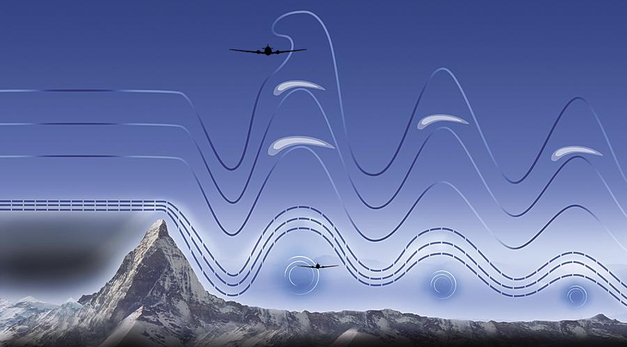

Here you can see the hydraulic jump off the mountain and then the wave vertically propagating. The rotor is formed below.
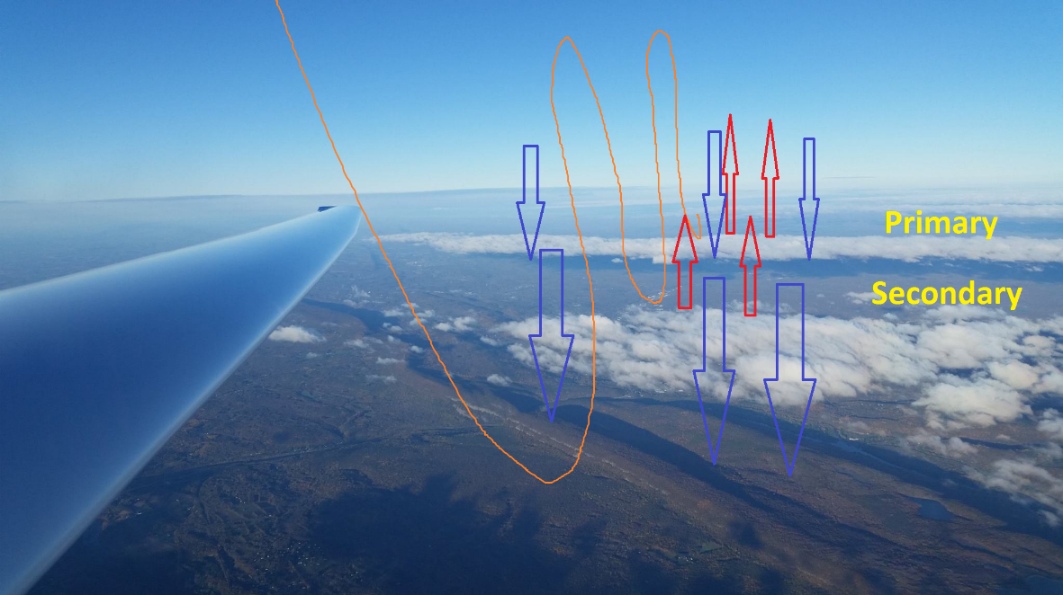
This is a photo taken in a tertiary wave, directly over Blairstown airport. The orange curve approximates the movement of the air and the arrows show the lift and sink.
Recognizing wave
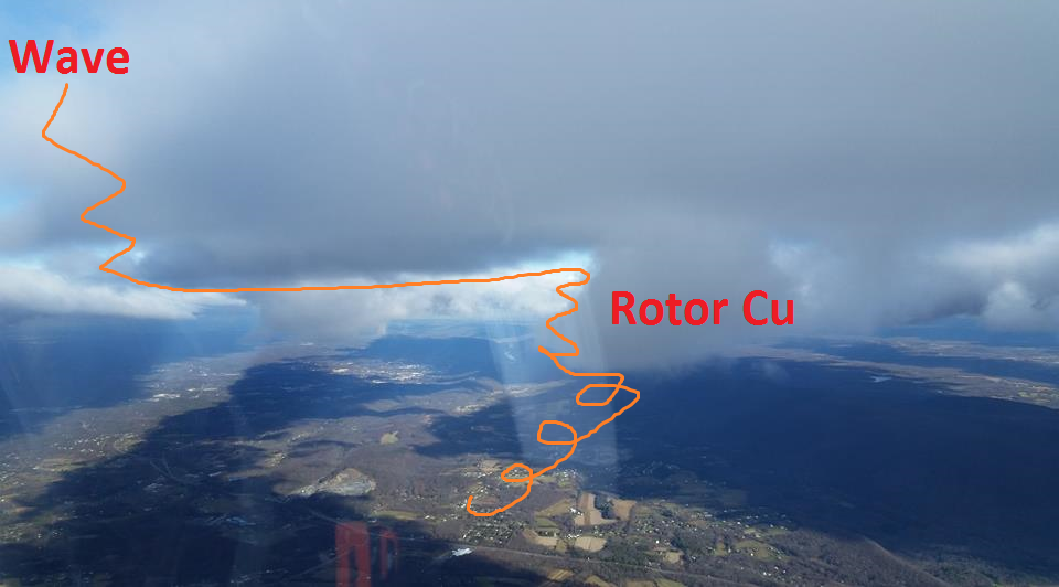
The first step to contacting wave is recognizing that it is there in the first place. To do this, one needs to recognize the cloud patterns and understand some of the mechanics in forecasting. In terms of recognizing wave in the sky, we often look for patterns in the clouds. The defining characteristics of wave are that the clouds remain stationary and parallel to the source that is creating the wave. The lifting action on the windward side creates the cloud, while the downward action on the lee side dissipates it. As a result, clouds created from wave formations appear to be stationary relative to the wind. When there is a lot of moisture in the air, the wave will create “windows” which are referred to as Foehn Gaps. When a wave is powerful, there may be numerous waves that will form downwind of the initial source. The first is referred to as the Primary and it is normally (but not always) the strongest. Then there can be Secondary, Tertiary, etc., going on for many miles downwind of the initial source.
The clouds that are most useful to help us contacting wave are the low level markers, particularly what marks rotor. Other than the wonderful silky smooth air associated with wave, the mixing of hot and cold air underneath wave clouds creates a turbulent churning action that is referred to as rotor. The rotor is a chaotic spinning cylinder that is integral to connecting with the wonderful wave lift. Under the upward side of the wave, the rotor will be largely rising. Clouds associated with rotor will look like raggedy Cumulus or disorganized rising tendrils. Just like the wave above, they will form over a consistent location.
Contacting Wave
Having recognized where the rotor and wave should be, now it is time to contact it. Whether the pilot is trying to work up into the wave from a low point, or is towing into it, often times the pilot will first end up climbing up the rotor before contacting the wave. The wave itself may form quite high and short of taking a 4500-5000ft tow, it will be requiring recognizing and taking advantage of the rotor.
While the lift in rotor is raggedy and inconsistent, it will be largely positive if you are positioned correctly. It is very important to recognize rotor because failure to do so will make working it incredibly frustrating. When in it, one will find bits of incredibly strong, but hard to work lift. When turning in it, it is not unusual to find 10 up on one side to then find 8 knots down on the far side of the thermal. This is normal and none of this is inherently attributable to thermalling skill. One just needs to be patient and keep the glider on the forward side of the rotor and slowly climb. It helps to mark the location where you find a good part of the rotor on your GPS or NAV-aid to come to remind yourself to park yourself in that location.
Once the rotor starts to peter out, having climbed up to cloudbase, it’s time to push forward and try to contact the wave. If all works out, you will hit weak silky smooth air. Initially, it may be very weak, perhaps even half of a knot in strength. Park yourself there and patiently work those several hundred feet. Think of the cloud as a ridge and you are well below crest. Once you start getting toward the middle of the vertical part of the cloud, the wave is likely to get stronger and stronger. This is often the strongest band in the wave and may go up to 5-10 knots or higher. It is very exciting when you get here!
Once in the wave, mark your position on your GPS and work your way up. Once above cloudbase, you’re safe to move around and try to find better lift. Often times, the first big surge in the wave will get you quite some height, but then it will start to weaken. When going for altitude, the challenge is to punch through these weakening layers and keep climbing.
Paradoxically, if you find an area that starts getting choppy, this is often an indication that the wave strength is likely to surge. The best explanation we have for this is that there may be a point where two waves are converging in a way that they are interfering with each other. Park yourself in the choppy area and patiently wait for it to surge again and keep climbing.
Waves will often be reinforced or interfered with depending upon the topography upwind. If the mountain gets higher in a certain place, it will often make the wave stronger and go higher in that area. Those are good areas to migrate to after initially contacting the wave. Furthermore, if you see these reinforced areas lower, often times it is easier to contact the wave there. Wherever the wave is stronger, it will tend to have stronger rotor and thermals underneath.
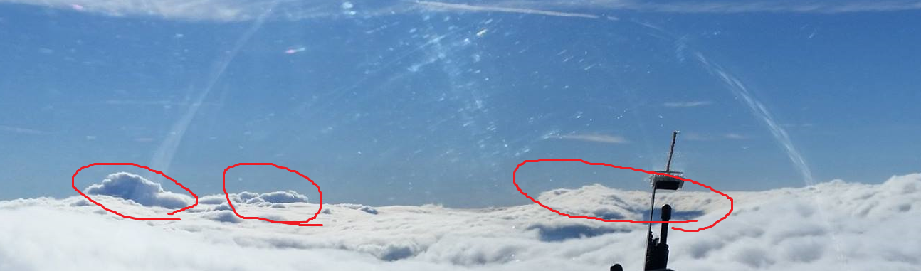
These higher clouds show areas where the wave is likely to be reinforced.
Hazards of Wave Flying
While wave flying is quite majestic and one of the most exciting experiences a soaring pilot can experience, there are a number of ways to get into trouble. Several relate to the flying and others relate to the physiology of being at altitude.
- Wave window closing-
When wave is marked by clouds, it makes it much easier to recognize and contact wave. However, if there is too much cloud, the Foehn Gap may start to close, leaving the unfortunate pilot stuck above. If a pilot becomes stuck on top with no outs, this can be a very dangerous situation as gliders are (typically) not equipped for instrument flight and the pilots lack the skills to safely fly in cloud. The pilot must be vigilant to make sure there are places where he can safely descend out of the wave. DON’T GET STUCK ON TOP!
- True airspeed-
As a glider gets higher, it needs to go faster to compensate for the less dense air. However, the glider cannot maintain structural integrity going faster. As a result, the redline starts to go down with altitude. Unless specifically listed in the aircraft manual, the rule of thumb is the redline goes down two percent per thousand feet. Failure to recognize this may lead to aero-elastic flutter of the controls or of the wings.
- Traffic-
We fly in busy airspace at Blairstown and there are quite a few arrivals that come through some of the best wave areas. Be vigilant for corporate jets and airliners.
- Severe rotor-
Rotor, especially near the ground can be particularly vicious. The stronger the wave, the stronger the rotor. While the waves at Blairstown do not tend to be all that strong, they can set up directly over the airport and make for a hellish tow. Many of the worst “ridge tows” we encounter are due to this strong rotor.
- Strong wind-
While waves can set up in many different sorts of conditions, the best will have strong winds from the WNW to North. This will make takeoffs and landings quite exciting and possibly dangerous.
- Sunset-
If flying late in the day, one must be vigilant to get down before sunset. It takes time to descend and the sun appears to be much brighter up higher due to being higher relative to the horizon.
- Descending quickly-
One should avoid descending very quickly in fiberglass gliders as this can shock the gelcoat. The gelcoat takes time to adjust to temperature and descending quickly may cause it to crack. While there is not an agreed upon amount of time that is appropriate, try to avoid pulling the brakes out fully and dumping into the lee.
Physiology:
- Oxygen-
Legally, one must have oxygen going above 14,000ft or spending more than half an hour between 12,500 to 14,000ft. However, it is generally accepted that it is unwise to be without oxygen going above 10,000ft. There are many considerations about the use of oxygen and I cannot accommodate all of them. However, lack of oxygen can be extremely dangerous. When flying high, the pilot is not acclimatized to the high altitude. Furthermore, being immobile does not cause the shortness of breath or headaches that normally afflict people climbing mountains at high elevations. As a result, the effects of hypoxia can creep up on the pilot without their awareness. The critical danger is that hypoxia diminishes the capacity for judgment, which further exacerbates the situation. Some people experience euphoria due to the lack of oxygen, which makes it difficult to recognize that they must come down immediately.
The common symptoms include the bluing of fingernails, shortness of breath, euphoria, headaches, and diminished color vision. While speaking on the radio, the pilot’s speech may become slurred. Don’t mess around with oxygen.
Listen to this clip of a pilot who is afflicted with hypoxia: https://www.youtube.com/watch?v=_IqWal_EmBg
- Cold
Temperature tends to decrease around four to five degrees Fahrenheit per thousand feet of altitude. It can get very cold, very quickly and it is important to be dressed for it. Aside from layers and warm pants/coat, it is important to have gloves and a hat. This helps a lot in retaining heat.
Forecasting Wave
Since we have an idea of some of the major variables that create wave, we look for those variables to be favorably represented in the forecast. The most important variables are wind speed at ridge top, wind gradient, and stability in the upper airmass. When these variables are solid, there is a good chance that there will be useable wave.
In general, the second day after a cold frontal passage is likely to be the most conducive for the best wave at Blairstown. The wind should be blowing over the Pocono plateau, while an inversion forms in the valley. This scenario is probably the most likely way for a high wave to form. Launching at dawn, there would be a three-hour window to climb in good wave conditions.
The most useful forecasting tool are:
MPO Winds: http://www.usairnet.com/cgi-bin/launch/code.cgi?sta=Kmpo&state=PA
Scranton winds aloft: http://www.usairnet.com/cgi-bin/Winds/Aloft.cgi?location=AVP&Submit=Get+Forecast&hour=24&course=azimuth
Soundings/Skew-Ts: https://rucsoundings.noaa.gov/
Click on “Interactive Plot”. Click “Load Soundings” and type in ABE for Allentown or MPO for Mount Pocono. I find GFS and the BAK40 to be the most useful models.
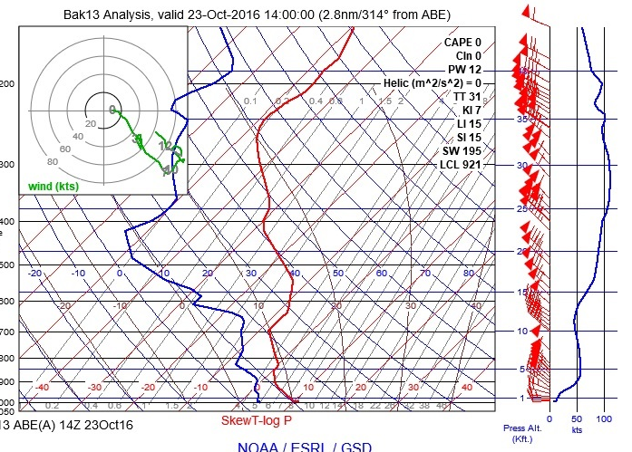
What we are looking for is a good wind gradient with altitude. Increasing winds aloft are represented on the far right side. Ideally, the line would be consistently rising with altitude, with little to no kinks down again. Secondly, we are looking for consistent wind direction. This is represented by the arrows. If the wind direction substantially shifts, this can kill the wave. Next, we look at the temperature profile, represented by the bold red line. Ideally that line should be either vertical or shifting to the right, as in getting warmer with altitude. When it shifts left, this could allow instability, which could break up the wave. Lastly, we look at the dewpoint to see where we may have moisture issues. Where the blue dewpoint line intersects with the red temperature line, there may be clouds. Pay particular attention to the lower part, as this could suggest that there would be wave windows. If they come very close together, there may be excessive moisture or there may be a high threat of wave windows closing.
Specifics of flying wave at Blairstown
Now that we have a background of what wave flying is all about, here are some thoughts about wave flying at Blairstown. In general, the Blairstown wave tends to be disorganized, rarely stationary and as I refer to it “rinky-dinky”. It is quite special when it sets up in a continuous line or when it propagates substantially into the higher airmass. Listed below are the places I have successfully contacted wave:

Wave tends to form either from our ridge, low-level plateaus or the Poconos. The most typical place we look for it is right over Blairstown Airport. This tends to be a pretty good spot, though sometimes it sets up closer to Rt. 94 or further back, over the railroad tracks. I have found wave three times in this area. Sometimes it is created off the main ridge, but other times it could be a wave propagating off the Poconos. If the wind is around 300 degrees, the plateau may focus the wave and the tertiary may set up right over Blairstown airport.
The wave will sometimes form off the foothills in front of the Delaware river. I flew this wave up near Sunrise Mountain. This wave can go quite a ways along the Delaware river valley, though it does not tend to go all that high. It is a low level wave, but can be quite useful to transitioning up to Wurtsboro.
Sometimes the wave will set up with a section intersecting Blue Mountain/Kittatinny. These areas are the best places to contact wave. On my recent wave flight on 11/27/16, I connected with the wave near Flying M. The ridge serves to reinforce the rotor/thermals that help you contact the wave, so keep an eye for wave formations that allow for that.
Others have had a lot of success finding wave near Cherry Valley airport. The theory is that this wave is coming off Camelback ski area. High wave climbs have been found off the Pocono Plateau and behind our main ridge. Bob Fitch climbed up to 16,400ft near the Camelback ski area. Several folks have gotten wave climbs above 12,500ft behind our ridge, some right over Blairstown.
There are other kinds of unique waves that have occurred that allowed very interesting flights. Bill Thar flew in a wave that formed on the edge of a front to 13,000ft. My recent flight on 11/27/16 seems to have occurred along the length of some sort of localized trough that created a small wave. These waves are very unusual and quite difficult to reliably predict. Once you have become a proficient mountain wave pilot, you may be able to take advantage of these more esoteric formations more easily.
Wave Pireps
I have written a number of reports of wave flights. They are reproduced below:
10/23/2016 Blairstown Wave to 17,913ft!
Today was by far one of the most extraordinary soaring days I had ever experienced at Blairstown Airport.
http://www.onlinecontest.org/olc-2.0/gliding/flightinfo.html?flightId=-191766570
Thanks to a mega-powerful departing low, it was clear that 10/23 out to have wave, albeit with 50-60 mph winds at 4000ft. That was scary for me the night before… I just imagined those winds mixing down to the surface and having to land with 50 mph gusts. Didn’t get a good night’s rest over that!
But getting up at dawn, there was no wind on the ground. The sky was absolutely clear other than a couple little rotor wisps. A crew of three of us (Schwartz, Boris Kubrak and I) launched at dawn to fly shortly after dawn. I had the fortune of flying Aero Club Albatross‘ prized LS4 today. I towed to 3700ft and released in the strongest and most consistent rotor I ever experienced. It was a solid 5 knots +, without much of the normal turbulence and craziness one would expect.
At 5200ft, I connected with the wave! I was staying stationary at 55-60 knots, climbing quite well. Looking out ahead, it was clear that I was in a tertiary wave, with the primary setting up over the Poconos. Maybe there was a way to get there?
The winds aloft were ferocious, but above 9000ft, they started to actually diminish in strength. Somehow the wave kept going and instead of hovering, I was now S-turning along the bar. More moisture was coming in and the waves were becoming much more defined. Furthermore, with the winds diminishing with altitude, it would make it easier to transition upwind.
Finally, at 12,800ft I peaked out in the tertiary and dove out to the secondary. I pushed the LS4 over to 100 knots to penetrate into the 70+ mph wind. I became keenly aware of the tiniest leak off the vent as the cold air seeped onto my feet. It was really freakin’ cold. The sun was on my back and I wasn’t expecting to get above 10,000ft!
Once I got to the secondary, I turned right and ran 65 knots along it. This was to get some sun into the cockpit and warm up! Also, I managed to get my shoes off and footwarmers in, and them back on. Took some contortions to do that, but it worked out nonetheless.
The secondary wasn’t all that strong, but at 11,000ft, it was enough to make the jump to the primary. So I dove out once more and I rode over the clouds to connect with the primary at 6500ft. I was able to find consistent areas of 4 knots, later decreasing to 2 and 3. At about 12,000ft, it would start to weaken again, but some moving around found an area of burbly air, going up a bit faster. John Good and Steve Beer at the Mt.Washington wave camp found that these areas are later followed by stronger wave and I hung with it for a while. Indeed they were correct!
At 13,000ft, I was climbing at 3 knots and the wind started to get stronger again. It became apparent that this wave may go high enough to beat the NJ state record (16,400ft!) set in 1983 by Bob Fitch! A little while later, I was still climbing at a solid 2.5 knots and was still going up solid at 17,000ft. The wind started to getting much stronger above 17,500ft, so I had to speed up to 55 knots and hover. But at 17,800, I was still climbing at 1.5 knots! Finally, I decided to do a little pull up to get to 17,900ft and then head down. Didn’t want to go higher in case there was a bit of an error in the logger and bust airspace.
If I wasn’t so cold, I would’ve hung around for a while longer, but I wasn’t dressed for 0 degree weather. So I headed to Hawk Mountain, in one long 10,000ft descent. There I picked up a little low level wave, which got my a bit beyond Pottsville, along Blue Mountain. Finally I dropped out of it, connected with a street and flew that up to Bear Mountain. Couldn’t climb off of Bear and by the time I made the tip, the wind shifted to 280 degrees. I figured that I took enough out of the day and decided to head back, thermalling with the tailwind.
I made it back most of the way thermalling, but dropped over Blue Mountain near the Blue Mountain ski area. I floated along in the high band at 2600ft or so and made it home around 2pm.
An absolutely fantastic day!
Thanks a million to Jimmy for towing and Aero Club Albatross for letting me fly this gorgeous ship! I would also like to note that all the wave flying at Mt.Washington has been instrumental in helping me recognize what the wave is doing and especially how it affects higher altitudes. Thanks again to Rick Roelke and the three clubs that organize it!
Wave 11/28/16
We had a really interesting wave formation at Blairstown yesterday. After flying down to Hawk and turning around due to weak wind and excessive moisture, I found wave near Flying M. It was never stationary and the “hydraulic jump” seemed to be happening at cloudbase. I explored it up to the Camelbak Ski Area, near Allentown, then up to Sussex and back. Highest I got was 7200ft, but mostly flying halfway above cloudbase at around 65-70 knots. Rarely perfectly smooth. The wave was also consistently drifting SE bound. My guess it was an atmospherically driven event, possibly a little front or trough coming through. Behind it, there was even more moisture coming through. Very fascinating!
Thanks a million William Thar for letting me fly your wonderful bird! Putting the nose down early in the day and going to 100 knots at ridge top was just sweet!
http://www.onlinecontest.org/olc-2…/gliding/flightinfo.html…
